
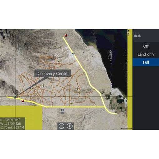

Located in East County San Diego, just to the east of Anza Borrego state park, lies the Ocotillo Wells State Vehicular Recreation Area (SVRA). This unique area is open to exploration by off highway vehicles across one of California's most popular tracts of BLM land.
Compatible with Lowrance HDS and Elite models.
Map Includes:
- 0.5-meter Aerial Imagery of Truckhaven and Ocotillo Wells SVRA
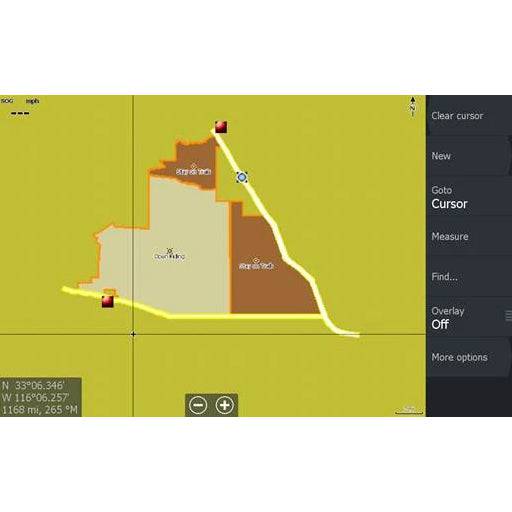
- Ocotillo Wells and Truckhaven OHV Boundaries
- Roads / Trails / Washes
- Campsites & Restrooms
- Pumpkin Patch
- Gas Domes
- Blowsand Hill
- 4x4 Trailing Area
- Notches.. and More!
Instructions
- Insert the card and if asked "Do you wish to change chart data selection to view inserted charts" Select yes.
- To change your GPS settings to show the satellite imagery on the HDS Live, Press Menu, Select More Options, Select Chart Options, Select Chart Detail, select Full. Select Photo Overlay and Select Full.
- When you change the map to be the satellite imagery - it is only reading that map. Your normal background mapping is not visible, only the area with the satellite imagery. To switch in between the two on the HDS Live, Press Menu, Select More Options, Select Chart Source. "C-MAP US..." is the factory map, "Lowrance" is usually the satellite imagery map.
Order processing times
Most orders will be processed in up to 72 hours. During seasonal times such as Black Friday, order processing time can take up to 5 business days. We appreciate your patience as we prepare your order.
Shipping times
Shipment dates & lead times will vary based on product availability, product may not be in stock. If you have a question regarding availability please email or call the office to discuss lead times. By completing payment, you have acknowledged the terms and conditions stated. As stock changes daily, we do not hold inventory, first come, first serve.
Currently some brands are experience major delays - contact us or more information.
Local pickup
We currently offer free pickup from our location. You will be notified via email or phone when your item(s) are ready for pickup.
Returns
We will accept returns within 30 days of original purchase and provide a store credit ONLY, no cash or credit card refunds will be given. All returns are subject to a 20% restocking fee. The product must still be in the original clean packaging, unused and uninstalled. We do not refund shipping and handling charges and the customer is responsible for all return shipping charges. There will be an additional rebox fee charged if the packaging needs to be replaced so please double box your returns. There is no returns of special order, tuners or custom parts.
Cancellations
Custom parts may not be canceled once your order is placed. Cancelled Orders may be subject to a 15% cancellation fee. All returns must be pre-authorized with a Battle Born Offroad Employee and have an RGA # or they will be returned to you. Refunds will be processed within 48hrs once product is received and in original condition. Most refunds are issued to the original payment method, or by check. Please allow up to 7 business days for store credit to reflect.
Website errors
In the event a product is listed at an incorrect price due to typographical, photographic, or technical error or error in pricing information received from our suppliers, Battle Born Offroad Ltd shall have the right to refuse or cancel any orders placed for product listed at the incorrect price.
Payment processing
By clicking checkout, you agree to have your payment ran anytime after checkout. Some orders may not be charged right away, and you authorize Battle Born Offroad to charge your card up to 365 days after completing your purchase for the maximum amount you paid.
SOME ORDERS DO NOT SHIP RIGHT AWAY
Most Orders will ship within 72hrs. Some parts may not in stock and may incur a 1-52 week time due to limited availability. If you want to check the most up to date lead times on any of these products please email us at info@BattleBornOffroad.net
How can I contact you if I have questions before ordering?
You can call us directly at 702-333-0868, email our support team, or message us on our chat or on social media. We’re here to help you with fitment, installation, and product questions before you commit to a purchase.
Do you price match other retailers?
Yes, we strive to offer the best prices in town. If you find a lower advertised price from an authorized dealer, let us know—we’ll do our best to match or beat it. Some exclusions may apply for clearance or special-order items.
What is your shipping policy and how long will my order take?
We offer free or discounted shipping on most orders over $99. Orders typically ship within 1-3 business days; once shipped, standard transit times depend on your location, but generally most transit time is 2-3 days. Expedited shipping is available at checkout, and offers delivery as quick as 24hrs. Tracking info will be provided once your package is in transit and will be sent electronically to your email.
Do you offer installation services or do you only sell parts?
Yes, Battle Born Offroad offers professional installation in our Las Vegas shop for ALL products we sell (suspension, lift kits, lighting, etc.). If you’re interested in installation, please hit our live chat button, give us a call at 702-333-0868 or email us to get a quote or get on the schedule. We can assist with shipping your vehicle to us if you are out of state and build trucks from around the country!
What warranty do your products come with?
All of our products come with a manufacturer’s warranty covering defects in materials and workmanship. Warranty durations vary by product and brand. Damage from misuse, improper installation, or off-trail abuse may not be covered. To initiate a claim or have questions, please reach out to us via email at info@battlebornoffroad.net and please submit photos, your order number and a brief description of the issue you are facing.
Do you offer financing or payment plans?
Yes, we partner with financing providers (Affirm, Shop Pay, SNAP Finance & Koalifi) so you can pay over time. Options like “buy now pay later” or longer-term payment plans may be available. Terms and interest will depend on your credit. Affirm and Shop Pay will be shown during checkout and must be clicked during this process. Other options are offered in store or on the phone, please feel free to call us at 702-333-0868 to discuss more.
How do you handle damages or defects in shipping?
Please inspect your package immediately upon arrival. If you notice any shipping damage, take clear photos of the damage and packaging and email us within 24 hours of delivery. We will work to make it right, either replacement of the part, or arranging return/reimbursement as needed.
Still have a question?
See all our Frequently Asked Questions or contact us with questions.
User Name 2 Days ago
Lorem ipsum dolor sit amet, consectetuer adipiscing elit. Aenean commodo ligula eget dolor.