




Don’t arrive at your destination. Discover it.
Built for every part of the journey, this extra big, extra rugged all-terrain navigator has the mapping you need to stay on track and communication technology to stay in touch while you’re out there.
OFF-ROAD RUGGEDNESS
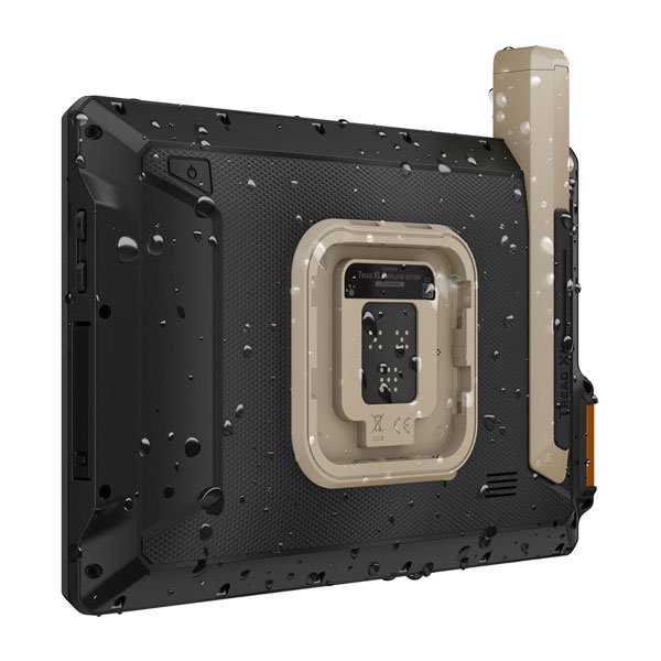
Purpose-built for all-terrain use, this Tread device stands up to anything the elements can throw at it. It’s IP67-rated for water-resistance.
HIGH-VISIBILITY DISPLAY
With its ultrabright 10” glove-friendly touchscreen, the navigator is designed for easy viewing in bright sunlight or pitch dark. It can be mounted in portrait or landscape mode.
TRAIL NAVIGATION
Enjoy turn-by-turn trail navigation for traversing unpaved roads and trails using adventure roads and trails map content comprised of OSM and USFS Motor Vehicle Use Maps.
BUILT-IN INREACH TECHNOLOGY
Built-in inReach technology offers global satellite communication3, two-way text messaging, location sharing and interactive SOS (active satellite subscription required).
MAPS ON AND OFF-ROAD
Tread includes preloaded topographic maps with 3D terrain for North and South America. It also includes detailed street maps of North America with custom routing for the size and weight of your rig2.
KNOW YOUR BOUNDARIES
Access U.S. public land boundaries for national forests, Bureau of Land Management (BLM), wilderness areas and more. Also, see U.S. private land boundaries and landowner information for parcels greater than 4 acres.
SATELLITE IMAGERY
Enjoy vivid aerial views when you download high-resolution satellite imagery directly to your device via Wi-Fi® connectivity, with no annual subscription required.
TRAIL RATINGS
Our growing trail database now includes difficulty ratings for off-road riding areas, where available, across the U.S.
SNOWMOBILE TRAILS
View snowmobile trail content for select areas within the U.S. and in Canadian provinces. This includes snowmobile-accessible locations such as fuel stops, warming shelters, restaurants and more.
OUTDOOR MAPS+
With a paid Outdoor Maps+ subscription, you’ll get ongoing access to a wide variety of additional premium map content. It is regularly updated and delivered directly to your Tread device via Wi-Fi® connectivity.
POINTS OF INTEREST
Tread comes preloaded with iOverlander points of interest and Ultimate Public Campgrounds, so you don’t need a cell signal to route to the best-established, wild and dispersed campsites.
ABC SENSORS
When you’re headed to tough-terrain, the built-in sensors will come in handy — including an altimeter, barometer, compass and pitch/roll gauges.
SECURE MOUNT
Use the included locking magnet-assisted mount to secure the navigator to your vehicle.
GROUP RIDE MOBILE
Track friends from your compatible smartphone or Tread device when you and your friends use the Tread app’s Group Ride Mobile feature.
EASY ROUTE PLANNER
Use the Tread app to easily plan routes with the same maps, vehicle profiles and route preferences that you have on the Tread device.
EASILY SYNC YOUR DEVICES
Use the Tread app to sync waypoints, tracks, routes and collections across all your devices. Easily import and share GPX files, too.
LIVE WEATHER
Weather ahead? Pair your Tread device with your compatible smartphone, and download the Tread app to access live weather, storm alerts, animated radar and more.
CONTROL YOUR ACCESSORIES
Pair Tread with the compatible Garmin PowerSwitch™ digital switch box (sold separately) to enable on-screen control for your vehicle’s 12-volt electronics — light bars, differential locks and more.
GROUP RIDE RADIO
Pair your device with the compatible Group Ride Radio (sold separately) for communication and tracking of other Tread-equipped riders in your group.
TRACK YOUR DOG PACK
Wirelessly pair Tread with select Garmin GPS dog trackers (sold separately) to help track and retrieve your sporting dogs in the field. You’ll see markers for each dog within tracking range, overlaid right on the navigator’s map screen.
EXPAND YOUR RANGE
Get enhanced performance with the robust external GPS antenna and external inReach® antenna. Both are in a low-profile, water-resistant housing and have many installation options. Each sold separately.
In the Box
- Tread XL - Overland Edition
- Suction cup mount
- Vehicle power cable
- Locking magnet-assisted mount
- USB-C cable
- Documentation
Specifications
| General | |
|---|---|
| Dimension | 9.9"W x 7.8"H x 1.2"D (25.2 x 19.9 x 3.1 cm) |
| Weight | 32.8 oz (930 g) |
| Water rating | IPX7 |
| Display Type | multi-touch, glass, high brightness HD color TFT with white backlight |
| Display Size | 8.5"W x 5.3"H (21.7 cm x 13.6 cm); 10.1" diagonal (25.7 cm) |
| Display resolution | 1280 x 800 pixels |
| Dual-orientation display | Yes |
| Magnetic Mount | locking magnet-assisted mount |
| 1.5-inch ball adapter with AMPS plate | Yes |
| Drop rating | MIL-STD-810 |
| Dust rating | IP6X |
| Battery Type | rechargeable lithium-ion |
| Battery life | Up to 6 hours at 50% backlight Up to 1 hour at 100% backlight |
| Maps & Memory | |
| Data cards | microSD™ card (not included) |
| Preloaded street maps | Yes |
| High-definition 3D terrain | Yes |
| 3D Terrain | Yes |
| Internal storage | 64 GB |
| Ability to add maps | Yes |
| External memory storage | yes (256 GB max microSD™ card) |
| Includes map updates | Yes |
| Downloadable Satellite Imagery | yes (BirdsEye) |
| BirdsEye Direct satellite imagery | Yes |
| TOPO map support | Yes |
| Sensors | |
| GPS | Yes |
| Galileo | Yes |
| Barometric altimeter | Yes |
| Compass | Yes |
| 10 Hz multi-GNSS positioning | Yes |
| Outdoor Recreation | |
| Preloaded topographical maps | Yes |
| Preloaded US public land boundaries | Yes |
| Preloaded private land parcel maps | yes (parcels greater than 4 acres) |
| Preloaded USFS Roads and Trails, including motor-vehicle-use-maps for motorcycle, ATV, SXS and full-size 4x4 | Yes |
| Navigate-a-track navigation | Yes |
| Turn-by-turn trail navigation | Yes |
| Mapping & Navigation | |
| Point-to-point navigation | Yes |
| Camera Features | |
| Backup camera compatible | yes (BC™ 50) |
| Navigation Features | |
| Garmin Real Directions™ landmark guidance | Yes |
| TripAdvisor® traveler ratings | Yes |
| Route shaping through preferred cities/streets | Yes |
| Includes traffic | yes (with Garmin Tread app) |
| Lane assist with junction view (displays junction signs) | Yes |
| Bluetooth® pairing | yes (works with BLUETOOTH-compatible helmet, headset or smartphone; BLE capable) |
| Speed limit indicator (displays speed limit for most major roads in the U.S. and Europe) | Yes |
| Advanced Features | |
| Smart notifications via app | Yes |
| Wi-Fi® map and software updates | Yes |
| Access to live services via app (traffic, weather, etc.) | Yes |
| Motorcycle Features | |
| Control music and media from smartphone or MP3 player | Yes |
| Sunlight readable and weather resistant | Yes |
| Garmin Adventurous Routing™ | Yes |
| Motorcycle or powersports specific points of interest for cycle repair services, dealers and more | Yes |
| Elevation profile | Yes |
| Round trip routing | Yes |
| Service History Log | Yes |
| Custom map support | Yes |
| RV Features | |
| Specialized routing for the size and weight of your vehicle | Yes |
| RV Parks & Services directory | Yes |
| Road elevations | Yes |
| Speed limit changes | Yes |
| Easy Route Planner with GPX file sharing | Yes |
| Adventure Features | |
| Built-in inReach® Technology (requires active subscription; subject to regulations or prohibitions in some jurisdictions) | Yes |
| Pair with Garmin PowerSwitch™ digital switch box | Yes |
| Compatible with Group Ride Radio | Yes |
| Compatible with external GPS antenna with mount | Yes |
| Compatible with external inReach® satellite antenna | Yes |
| Group Ride Mobile | yes (with Garmin Tread app) |
| Track recorder (breadcrumbs) | Yes |
| iOverlander™ points of interest | Yes |
| Ultimate Public Campgrounds | Yes |
| Pitch and Roll gauges | Yes |
| Birdseye Satellite Imagery (download via Wi-Fi) | Yes |
| Glove-friendly touchscreen | Yes |
| Outdoor Applications | |
| Dog tracking | yes (when paired to compatible dog track system) |
1. Limitations may exist in map data for some road and trail route suggestions. Always defer to all posted road signs and conditions during vehicle operation. The Garmin OpenStreetMap products are intended to be used only as a supplementary travel aid.
2. Not available in all areas. Entering your vehicle’s profile characteristics does not guarantee your vehicle’s characteristics will be accounted for in all route suggestions. Always defer to all posted road signs and road conditions.
3. Active satellite subscription required for the inReach features. Some jurisdictions regulate or prohibit the use of satellite communications devices. It is the responsibility of the user to know and follow all applicable laws in the jurisdictions where the device is intended to be used.
4. The CES Innovation Awards are based upon descriptive materials submitted to the judges, CTA did not verify the accuracy of any submission or of any claims made and did not test the item to which the award was given.
5. Copyright © 2026 by iOverlander, LLC. Satellite Imagery © 2026 Vantor (date of satellite imagery may vary). Wi-Fi is a registered trademark of the Wi-Fi Alliance. Copyright © 2026 Ultimate Campgrounds - All rights reserved. The Bluetooth word mark and logos are registered trademarks owned by Bluetooth SIG, Inc. and any use of such marks by Garmin is under license.
Order processing times
Most orders will be processed in up to 72 hours. During seasonal times such as Black Friday, order processing time can take up to 5 business days. We appreciate your patience as we prepare your order.
Shipping times
Shipment dates & lead times will vary based on product availability, product may not be in stock. If you have a question regarding availability please email or call the office to discuss lead times. By completing payment, you have acknowledged the terms and conditions stated. As stock changes daily, we do not hold inventory, first come, first serve.
Currently some brands are experience major delays - contact us or more information.
Local pickup
We currently offer free pickup from our location. You will be notified via email or phone when your item(s) are ready for pickup.
Returns
We will accept returns within 30 days of original purchase and provide a store credit ONLY, no cash or credit card refunds will be given. All returns are subject to a 20% restocking fee. The product must still be in the original clean packaging, unused and uninstalled. We do not refund shipping and handling charges and the customer is responsible for all return shipping charges. There will be an additional rebox fee charged if the packaging needs to be replaced so please double box your returns. There is no returns of special order, tuners or custom parts.
Cancellations
Custom parts may not be canceled once your order is placed. Cancelled Orders may be subject to a 15% cancellation fee. All returns must be pre-authorized with a Battle Born Offroad Employee and have an RGA # or they will be returned to you. Refunds will be processed within 48hrs once product is received and in original condition. Most refunds are issued to the original payment method, or by check. Please allow up to 7 business days for store credit to reflect.
Website errors
In the event a product is listed at an incorrect price due to typographical, photographic, or technical error or error in pricing information received from our suppliers, Battle Born Offroad Ltd shall have the right to refuse or cancel any orders placed for product listed at the incorrect price.
Payment processing
By clicking checkout, you agree to have your payment ran anytime after checkout. Some orders may not be charged right away, and you authorize Battle Born Offroad to charge your card up to 365 days after completing your purchase for the maximum amount you paid.
SOME ORDERS DO NOT SHIP RIGHT AWAY
Most Orders will ship within 72hrs. Some parts may not in stock and may incur a 1-52 week time due to limited availability. If you want to check the most up to date lead times on any of these products please email us at info@BattleBornOffroad.net
How can I contact you if I have questions before ordering?
You can call us directly at 702-333-0868, email our support team, or message us on our chat or on social media. We’re here to help you with fitment, installation, and product questions before you commit to a purchase.
Do you price match other retailers?
Yes, we strive to offer the best prices in town. If you find a lower advertised price from an authorized dealer, let us know—we’ll do our best to match or beat it. Some exclusions may apply for clearance or special-order items.
What is your shipping policy and how long will my order take?
We offer free or discounted shipping on most orders over $99. Orders typically ship within 1-3 business days; once shipped, standard transit times depend on your location, but generally most transit time is 2-3 days. Expedited shipping is available at checkout, and offers delivery as quick as 24hrs. Tracking info will be provided once your package is in transit and will be sent electronically to your email.
Do you offer installation services or do you only sell parts?
Yes, Battle Born Offroad offers professional installation in our Las Vegas shop for ALL products we sell (suspension, lift kits, lighting, etc.). If you’re interested in installation, please hit our live chat button, give us a call at 702-333-0868 or email us to get a quote or get on the schedule. We can assist with shipping your vehicle to us if you are out of state and build trucks from around the country!
What warranty do your products come with?
All of our products come with a manufacturer’s warranty covering defects in materials and workmanship. Warranty durations vary by product and brand. Damage from misuse, improper installation, or off-trail abuse may not be covered. To initiate a claim or have questions, please reach out to us via email at info@battlebornoffroad.net and please submit photos, your order number and a brief description of the issue you are facing.
Do you offer financing or payment plans?
Yes, we partner with financing providers (Affirm, Shop Pay, SNAP Finance & Koalifi) so you can pay over time. Options like “buy now pay later” or longer-term payment plans may be available. Terms and interest will depend on your credit. Affirm and Shop Pay will be shown during checkout and must be clicked during this process. Other options are offered in store or on the phone, please feel free to call us at 702-333-0868 to discuss more.
How do you handle damages or defects in shipping?
Please inspect your package immediately upon arrival. If you notice any shipping damage, take clear photos of the damage and packaging and email us within 24 hours of delivery. We will work to make it right, either replacement of the part, or arranging return/reimbursement as needed.
Still have a question?
See all our Frequently Asked Questions or contact us with questions.


User Name 2 Days ago
Lorem ipsum dolor sit amet, consectetuer adipiscing elit. Aenean commodo ligula eget dolor.